My most recent adventure brought me to the Redding Waterfall Loop, and I was able to almost complete it within one three-day weekend!
In case you're wondering, the Redding Waterfall Loop is a series of 13 waterfalls that can be accessed at least an hour from the city of Redding, in Shasta County, Northern California. These waterfalls coincidentally form an almost perfect loop when the starting point is in Redding itself. However, they cannot be all accessed within one day, or even in two days.
So, did I ever mention that I have time management down to a science?
I spent several days studying this loop and strategically planning out my various lodgings so that I could see as many in a single day as possible. I also took the time to study the locations of these falls and the best means of reaching them, if there were any fees involved, and, very importantly, where the closest bathrooms were!
I had meant to post this earlier but wound up being cast in a play, so this post is a little late and I apologize. I also need to split this post in half, so this post will focus solely on the falls, while the next one will be the guides to these falls.
And now, let's take a look at these wonders of nature!
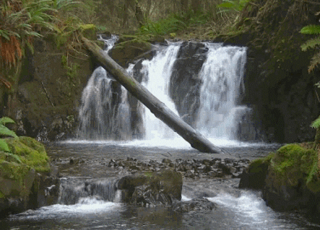
The Falls that Comprise the Redding Waterfall Loop
Redding is in one of the most strategically beneficial places for seeing the best waterfalls outside of Yosemite in California. The city's tourism website has a map listing the dozens of waterfalls within 1-2 hours of the city, but the official loop only lists 13. This list, while informative, is not entirely up to date anymore.
Of these 13 waterfalls, 12 are accessible, and 1 of those 12 can only be accessed by SUVs. Here's a list of the 13 waterfalls:
Hatchet Creek Falls
Little Backbone Creek
Eleven of these 13 falls are easily accessible, so I believe that this loop should be updated. In my travels, I came across another waterfall that I think should be on the list, and one other that I wasn't able to see for myself but should be included on the list.
Also, with my description of the various falls, the lengths of the trails will be based on my health app records.
So, without further ado, let us begin!
First Things First: The Inaccessible Falls
This falls loop is comprised of some incredible waterfalls, but sadly, one of them is permanently closed: Hatchet Creek Falls. These falls were on private property, and due to fire damage and stupid visitors, the owners felt the need to close off their grounds. While tragic, this should prove a lesson to all travelers and hikers: when on private property, show the utmost respect for the area, and leave no trace! Areas like this are unique and beautiful, and should be kept as such!

The next waterfall that is not quite accessible, but almost is, is Little Backbone Creek. I add this to this list because the road that leads there is an ATV road. If you have an ATV, dirt bike, motorcycle, truck, or any other type of sturdy SUV, you can make it there. But if you drive anything other than those (like myself), you will NOT be able to reach these falls. The main road drops at about a 45 degree angle!

There is another means of reaching a trail to go there, but that one is blocked off with "no trespassing" signs. So while you can still reach this particular waterfall, be prepared for an extremely bumpy ride, and make sure that you have the right vehicle to get there. Otherwise, you'll probably wind up with more damage to your car than it's worth!
This waterfall can also be accessed by boat if you want to skip the drive altogether.
Before You Begin the Trip
This being a trip that focuses on waterfalls, keep in mind that waterfalls means lots of water!
Since California has been suffering from droughts the last few years, the best time to visit these falls would be between mid-April to early June. After June, most of these falls will likely be dried up or little more than a trickle.
You will also need waterproof and slip resistant boots. Some of these falls even require you to hike upstream without a trail, or even over rocks, but even with slip-resistant boots you will likely slide here and there. Hiking poles are also recommended for the hikes over the Pacific Crest Trail, or PCT for short.
Personal Descriptions of the Waterfalls
Waterfall 1: Root Creek Falls

Parking: There are two parking lots. The first is free, but the exit is a one-way road, so you have to pass the offramp, take the next exit, then go right back onto I-5 South and take the exit, then immediately park in the dirt lot on the right. If you miss it, you need to loop around back to the lot, or go to the other option.
The second lot is part of the Castle Crags State Park. This lot has a fee of $10 per vehicle.
Trail Length: 5 miles from I-5, 4 miles from the State Park; from the park follow the signs to the PCT junction.
Trail Difficulty: Starting from the I-5 parking lot is steep, giving this portion of the trail a moderate difficulty. If you start from the Castle Crags lot, the trail is more level. On the whole, once you reach PCT, the trail is easy enough for kids to handle.
Bathrooms: No bathrooms at the first lot off of I-5, but there are some at the Castle Crags Lot. There is also a Chevron station at the Castle Crags exit that has accessible bathrooms.
Hazards: Slippery rocks, poison oak
Cell phone coverage: Limited
Special notes: If you park at the Castle Crags lot, the trail to the falls is 90% wheelchair accessible. When you are within .2 miles of the falls, the trail is no longer wide enough for wheelchairs, but despite the roughness, a person in a wheelchair may still be able to reach the lower falls, where the trail dead ends.
My review: The lower falls were beautiful, but to reach the main falls was dangerous. I couldn't go far above the most accessible area without slipping and sliding everywhere. If you travel with a group, you could probably make it to the main falls without having to worry too much. Traveling alone, however, is a different story. If you hurt yourself trying to reach the main falls, or traveling back to the trail, you're still several miles from anyone who could help. It's your call if you go alone.

Waterfall 2: Burstarse Falls

Parking: A decent sized lot can be accessed from Castle Creek Rd. From there, you can reach the Dog Trailhead, which leads to PCT.
Trail Length: 5.26 miles.
Trail Difficulty: The first .5 miles are brutally steep and rocky both going up and down, but once you reach PCT, it's much easier.
Bathrooms: There is a Chevron station right at the I-5 exit that has accessible bathrooms.
Hazards: Loose rocks, slippery rocks, poison oak, bugs
Cell phone coverage: Limited
Special note: This trail can also be accessed from the Castle Crags parking lot. Follow the signs for PCT for a longer but easier hike.
My review: These falls were truly amazing! Even though the main falls, like Root Creek, were further up the hill and had to be traversed off-trail, they were still very beautiful at Burstarse Creek. The lower falls are more than satisfactory, but going further up alone is not recommended, as the risk of injury isn't worth being stranded in the wilderness for. Again, it's your call.

Waterfall 3: Hedge Creek Falls

Parking: A small lot is available directly across the street from the trail to the falls. Depending on the time of day, it can be full up, so you would need to find street parking on one of the side streets of Dunsmuir Ave. to the southwest. These is no street parking to the northwest.
Trail length: 0.6 miles
Trail Difficulty: Easy
Bathrooms: None
Hazards: None
Cell phone coverage: Moderate
Special notes: There have been plans on the back burner for years that would connect Hedge Creek Falls with Mossbrae Falls, but as of now there's still no development. There isn't much else to this area outside of the falls, though the trail does explore the creek as it flows into the Sacramento River. There's also a platform where you can have a river view of Mt. Shasta.
My review: This waterfall is definitely worth checking out. It has an adventure movie feel to it, and depending on how much time you have, you can spend as little as 15 minutes there and have a satisfactory experience.

Waterfall 4: Mossbrae Falls

Parking: Google Maps will take you to Shasta Retreat on Scarlet Way, but this is private property and there are signs all over stating that there is no waterfall parking allowed. There is street parking on Dunsmuir Ave. not too far away, but make sure that you are definitely in a parking zone as some areas are designated as "no parking."
Trail length: 2.9 miles
Trail Difficulty: Easy, though the trail isn't your expected trail; it goes alongside the Pacific Railroad. The way is covered in rocks and can be extremely narrow between the river's edge and the tracks, making for a rough walk.
Bathrooms: None
Hazards: The railroad. Stay on the river side of the tracks and don't go on the canyon side. You will hear any trains approaching with their horns, and also the tracks will start to crackle with electricity before the you hear the horns. Do not have earbuds in or headphones on while going this route!
Cell phone coverage: Minimal
Special notes: This route is on private property, but Pacific Railroad allows people to visit the falls so long as you do so safely. Some people have been dumb enough to not take their safety seriously when the train approaches. If you hear a train approaching, find an area that will allow you a wide enough berth for the train to pass. Since the conductors are aware of the pedestrian traffic, they will often times wave at the people passing. So wave back!

My review: There is something absolutely magical about these falls. Unlike the rest of the falls on this list, which are all fueled by creeks, rivers, and lakes, this one is made up of natural springs! The fact that the water comes directly from the earth, combined with the unique way the moss and foliage drapes from the side of the hill, adds an ethereal sense that makes you react with awe and feel uncommonly calm.
Considering how hazardous the trek is to this waterfall, I would plan on taking extra time to spend there once you reach the falls, and bring a lunch or snack depending on the time of day you visit.

Waterfall 5: Faery Falls

Parking: There is a very large lot here, though the road is very rough and remote.
Trail length: 1.3 miles
Trail difficulty: Easy
Bathrooms: None, though there are several gas stations and restaurants in the town of Mt. Shasta that you may be able to access.
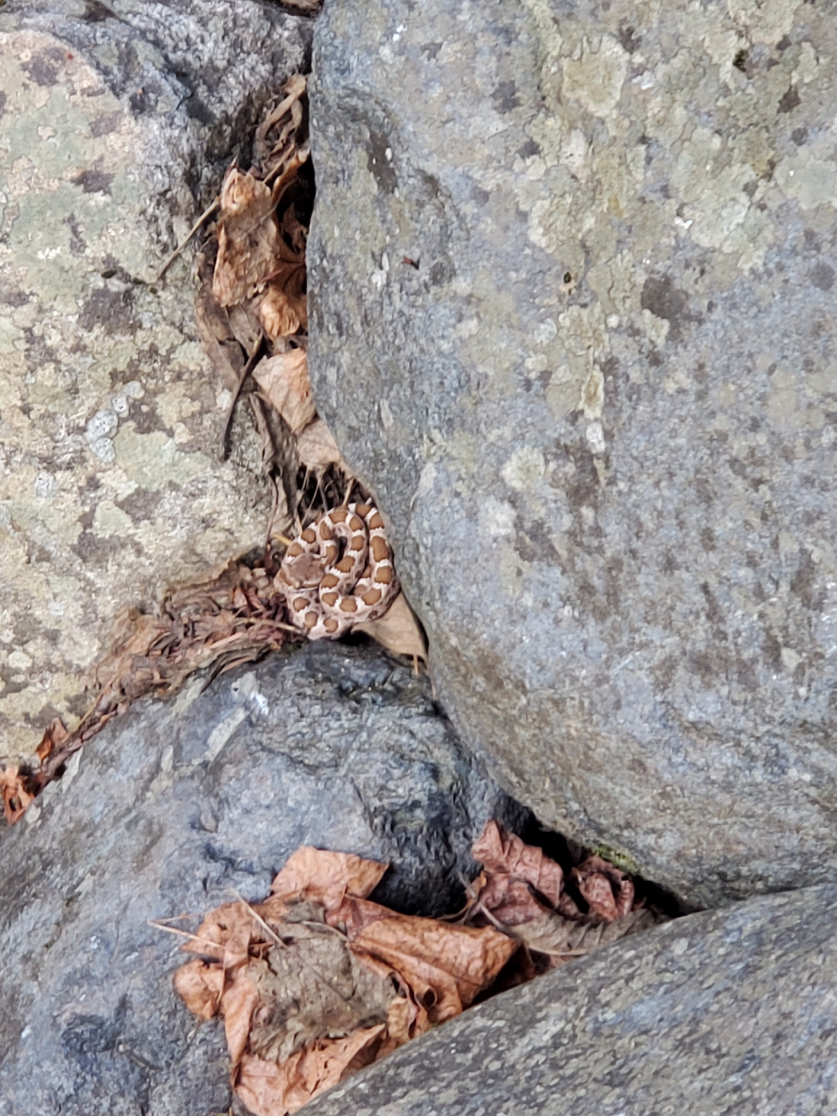
Hazards: Slippery rocks, bugs, snakes
Cell phone coverage: None
Special notes: The parking lot is at the foot of the of Ney Springs, which is a nice place to relax if you have the time. The main falls are further up the trail from where the trail supposedly tells you where the falls are, so keep going further after reaching the lower falls. I missed this due to this being my last waterfall of the day and having already hiked 15 miles, so I was too mentally tired to realize I could go on further.
My review: These falls are far out enough to bring some relaxation after a long day, so if you want a waterfall with no distractions and plenty of places to explore, this is a good one. There is also a natural well with a bubbling spring that is worth checking out here. Please be careful if you try climbing over the rocks, as these ones were more slippery that the rocks at the previous falls.

Waterfall 6: Lower McCloud Falls

Parking: There is a moderately sized lot here with spaces large enough for trailers and mobile homes, and there are no fees. However, this lot tends to fill up very quickly so it's best to arrive early since there's little to no street parking available.
Trail length: There isn't much of a trail to this waterfall as it's immediately accessible from the parking lot by a short path. However, if you want to do the full McCloud trail, going from lower to middle to upper, the round trip is 4.6 miles.
Trail difficulty: Easy. Of all the trails on this loop, this one is the easiest and safest to access.
Bathrooms: There are vault toilets at this location with no sinks. There is a water spigot outside of the toilets so you may want to bring your own soap and towel; otherwise have hand sanitizer with you. The trail also passes several camp sites which also have vault toilets.
Hazards: If you want to go down to the falls, you'll have to climb over plenty of rocks. There is a chance of slipping on these rocks if you aren't careful.
Cell phone coverage: Minimal
Special notes: You can save time by visiting each one of the McCloud Falls individually by driving, as each waterfall has its own parking lot.
My review: If you start at the lower lot, the falls only get better as they go. I would highly advise starting at the lower falls and making your way up from there.

Waterfall 7: Middle McCloud Falls

Parking: There is a small parking lot at this location with no fees.
Trail length: 0.7 miles
Trail difficulty: Midway between easy and moderate. The trail is down and up, and coming up can be a little strenuous.
Bathrooms: Vault toilets
Hazards: Slippery rocks
Cell phone coverage: None
Special notes: If you want to hike but still save some time, drive from the lower falls to the middle falls, then hike from the vista point to the trail that links up to the vista point at the upper falls. It's an easy, lovely little hike that only clocks at 0.65 miles there, bringing your total hike to 1.3 miles.
My review: Of the three tiers of the McCloud Falls, this one is the best. It is the largest and the most impressive, though climbing over the rocks for a better look is more hazardous than the lower falls. Proceed with caution!

Waterfall 8: Upper McCloud Falls

Parking: There is a small parking lot at this location with no fees, though driving here from the middle falls doesn't offer as good of views as the small hiking trail linking the two segments.
Trail length: No trail, just the vista point unless you hike from the middle falls.
Trail difficulty: None
Bathrooms: Vault toilets
Hazards: None, though the trail connecting the upper and middle falls can be a little narrow if you choose to use it.
Cell phone coverage: None
Special notes: The connecting trail is the best means of seeing this waterfall.
My review: The upper falls are a wonderful sight to behold, though it's a little dangerous to access. The creek above the falls is inaccessible, though the pool below makes for a nice swimming hole.

Waterfall 9: Rock Creek Falls (not on official list)

Preface: Since Hatchet Creek Falls is closed to the public, I did research to see if there were any other waterfalls that could be found between the listed waterfalls. My searches brought me to Rock Creek Falls, and I personally went out to investigate these falls and feel that they should be included on the official loop as it is an impressive waterfall.
Parking: The trail is at a remote PCT junction on a rough road, so there is street parking only, though there was at least one area that looked like it could handle about 2-3 smaller cars.
Trail length: 0.9 miles according to my health app
Trail difficulty: Easy
Bathrooms: None
Hazards: Narrow trail, slippery rocks, no shade
Cell phone coverage: Minimal to none
Special notes: Google Maps will bring you to the waterfall, but there will be no means of accessing it safely. Further down the road is a campsite along the creek but there is no trail beyond that. The safest access point is, as said above, at an easy-to-miss PCT junction.

For this very reason, I took a picture of the PCT junction and the Google Maps location of how to reach this trail in case you would like to check it out for yourself.

My review: I'm surprised that this waterfall wasn't included in the original loop because it is a grand sight. It also doesn't have any trail listed on AllTrails, Hiking Project, Komoot, or Gaia. Regardless, it is a quick hike across PCT that few people will be checking out unless they're also traveling PCT. You will likely be the only person on this trail if you do check it out, so please be very careful when going over the rocks for better views.

Waterfall 10: Burney Falls

Parking: There are two parking lots at the McArthur-Burney Falls Memorial Park, and it costs $10 to enter. The first lot is right at the trail down to the falls, while the other is further on the Lake Britton Shore. Depending on the time of day and how busy it is, you may be lucky enough to snag a space closer to the falls, but if there's no parking available, there is a trail that will lead to the falls from the Lake Britton lot.
Trail length: For Burney Falls, the loop trail is 1 mile, with options to do other trails along the river. If you have to park at Lake Britton, the Rim Trail is an additional 2.5 round trip trail, bringing the full trip to just over 3.5 miles.
Trail difficulty: The falls loop trail is easy, though the Rim Trail is of a more moderate level.
Bathrooms: Available at the visitor's center and Lake Britton campground.
Hazards: Some of the outlying trails are closed due to weather damage. It's best to stay away from the closed trails until they are safe to reopen.
Cell phone coverage: None
My review: Not to be missed! The massive size and overall grandeur of this waterfall is positively breathtaking. There are a lot of people there who will be swimming, fishing, and taking pictures, so sometimes the pedestrian traffic can be a bit much. Still, when you see this waterfall after viewing so many pictures of it, you'll see that the pictures can hardly do the real thing justice. Even with all the vehicle and pedestrian traffic, this waterfall is a must-see at any time of year.

Waterfall 11: Montgomery Creek Falls

Parking: This waterfall is on a private drive, so there isn't much in the way of parking. There is a bridge on the drive, and the road before the bridge is wide enough to allow for some street parking. Going over the bridge, however, is private property. Make sure you don't trespass.

Trail length: No trail, the falls are right off the bridge.
Trail difficulty: While there is no trail, the falls cut through a rocky crevice, and finding a way down to the rocky ridge can be tricky.
Bathrooms: None, though there is a rest area in Hillcrest off of Highway 299 a few miles away.
Hazards: The lack of a proper trail makes finding a good vantage point for the waterfall on either side can be precarious. Proceed with caution.
Cell phone coverage: Moderate
My review: This one may be easy to reach, but being so close to private property, and its lack of safety features, it is the one waterfall on the list that the least amount of time should be spent at. The dirt surrounding the sides of the falls is loose, so it is very easy to slip and lose your footing. It's a magnificent waterfall, but not worth risking your safety for. Take a few minutes and some pictures, then move on.

Waterfall 12: Potem Falls

Parking: There is a small parking lot right at the trailhead. There are no fees, but the road there is long and extremely rough, though not the worst I've driven.
Trail length: 0.67 miles
Trail difficulty: Varies between easy and moderate. The way down is fairly easy, though going back up is a bit of a strain.
Bathrooms: None
Hazards: Poison oak everywhere. Do NOT leave the trail!

Cell phone coverage: None
My review: This was the perfect waterfall to end the day with. It was remote, beautiful, and overall, serene. You can see the falls right from the trailhead, and once you make it down to the pool below the falls, you can relax with the sound of nothing but the rush of water.
Unfortunately, my experience was tainted by a horribly timed thunderstorm. It began to rain lightly right as I appeared, and I had barely been down at the waterfall 5 minutes before the thunder rumbled. I had to hustle back to my car before the weather became worse.
I would have liked to spend more time at this waterfall, and fully intend to return soon.

Coming Up Next!
I hope you've enjoyed my personalized experience with the Redding Waterfall Loop! It was such an amazing and life-changing experience seeing these waterfalls, and I would definitely recommend seeing at least one or two of these falls if you're in the area. California is known for so many beautiful areas, but these waterfalls are truly hidden gems.
Next, I'll have guides to how to best utilize your time seeing these waterfalls depending on how much time you have. This will be posted sooner rather than later since it took me so long to write this one, so check back, and be prepared to plan an adventure of your own to see these wonderful and lesser known marvels of nature!
All of these pictures were taken by me and not to be used except by me. Gifs courtesy of Giphy.